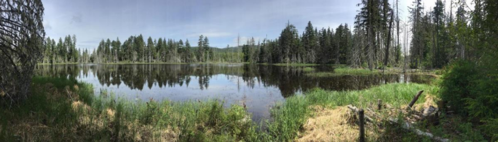
The Xwulqw’selu Watershed covers just over 300 square kilometres from the western mountains to Salish Sea.
The 44 km-long Koksilah River is comprised of many smaller, interconnected drainage basins — where mountains and hillsides are like the edges of a bowl, guiding water to flow downward into streams, aquifers, lakes to the river and eventually to the sea.

History of the Land
Thousands of years ago, Syalutsa, the first Quw’utsun’ person fell from the sky and landed near Xwulqw’selu (Koksilah) ridge. Not long after, he was followed by his younger brother, Stuts’un, who landed on Swuqus (Mount Prevost). Among the first lessons that Syalutsa and Stutsun were taught by the Creator was to perform kw’aythut (spiritual bathing) “in every little stream, river or lake” (Marshall 1999, p. 16) in order to connect with and learn from spirits, and the land upon which their lives depended. In addition to kw’aythut, Syalutsa taught his brother Stutsun to take only what is needed from the land. Together, these practices allowed the brothers to better understand their place in the world, a teaching that would be passed on to their descendants for generations to come.

Quwu’tsun History
Historically significant places that are specific to the Koksilah watershed include the Koksilah village (Xwulqw’selu), a winter village site, which is still located where the current Highway 1 intersects with the Koksilah River Written records refer to as many as seven longhouses in the Koksilah village during the mid-1800’s and to at least one longhouse in use during the early 1920’s. Two longhouses were located at the soon-to-be built Cowichan Station railway stop, but were deconstructed when the E&N railway was built.
Other notable places include Marble Falls (xtem’ten) where seasonal salmon fishing camps were located, Q’up-q’upasum’, currently known as Cowichan Station near Moss Road, was a gathering place where a fishing weir was located
Busy Place Creek (Sh-hwuykwselu) was an important meeting spot and transportation corridor, and prior to industrialization of the area, provided a physical connection between the Cowichan and Koksilah rivers


Historic Forests & Ecosystems
Forest composition in the Koksilah watershed varied over time and space. Lower elevation ecosystems (generally below 150 m) were likely a mosaic of prairie, plains, open forest, and dense forest (Bjorkman and Velland 2010). Large Douglas-fir trees with thick fire-resistant bark were dispersed throughout the fire-maintained plains and open forests. The more densely forested areas at elevations above 150 metres were typically comprised of Douglas-fir interspersed with western red cedar, grand fir, and small amounts of western hemlock.
Cooler, north-facing slopes and riparian areas would remain unburned for periods between 700- 1000 years, while drier slopes burned every 350 years or so. As a result, forests over 100 years were common across the landscape.
The majority of land in the Koksilah watershed is still privately owned, the history of which dates back to the granting of Vancouver Island to the Hudson’s Bay Company (HBC) for safeguarding British interests in 1849.
Read the Reports
The Koksilah River watershed is a place of deep human history and immense ecological richness.
Learn about the context and rationale for a network of protected areas designed for the Koksilah River watershed.
Sign up for all the Koksilah Watershed News!
Hear about upcoming meetings, special events and ways to get involved